HDTV Coverage
This predicted coverage map shows generally where the WLT translator signal will be usable. The red circle is centered on Glenada Hill where our communications tower is located.
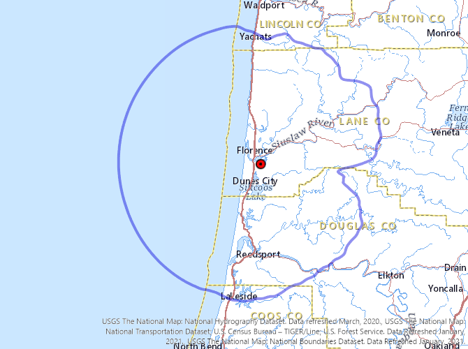
Note that this is “predicted” coverage, not “measured” It is calculated mathematically using data about the antenna design, antenna height, transmitter output power, and topographic features from 2 to 10 miles away from the transmitter location.
Because the calculations don’t take into account terrestrial obstructions beyond 10 miles from the transmitter, they don’t recognize distant obstacles, such as, for example, Cape Perpetua being a small impediment to our signals getting into Yachats. Even nearby locations can be much different from the predicted coverage. The coverage map clearly indicates that our transmitters should reach Mapleton, 13 miles inland from Florence, but because of shielding terrain, there is no signal there. Two of the Eugene TV stations operate separate translator facilities to provide service to that community.
On the other hand, the signal strength out to sea is probably understated. Without hills and trees, it’s likely possible to receive a great picture all the way to the horizon and a bit beyond.
Locations such as Siltcoos Lake, and other hilly environs will experience hit-or-miss propagation, depending on which side of a hill you might be on, and the elevation of your site.
In the future, we hope to update this map with an improved version that takes into account more accurate terrain modeling but it still will not account for very localized conditions (such as the majestic trees that have grown tall enough to block your antenna’s clear view of our tower). You’ll be able to get the most accurate information about reception by trying it out and we hope that the information on our HDTV How-To and HDTV Antennas pages will be helpful in your efforts.
The tools on TV Fool may be useful for getting information specific to your exact location.